Start with the Official Map, Then Check Access
The fastest way to find a usable fishing spot is to start with the official map for the province you plan to fish, not with a random satellite screenshot. In Ontario, Fish ON-Line helps anglers plan trips across more than 18,000 waterbodies. In British Columbia, the GoFishBC Where to Fish map lets you filter stocked lakes by road access, boat launch, dock, campsite, washroom, and more.
After you find a likely waterbody, check three things before you leave home: where you can legally park, whether the shore or launch is public, and whether that water has local regulations or seasonal closures. A productive lake is not much use if the access is private, blocked, or outside the open season.
The Official Tools Worth Using First
Ontario — Fish ON-Line: This is one of the most useful public fishing tools in the country. Ontario says it can be used to plan trips, check regulations, and get directions to more than 18,000 waterbodies and licence vendors. It is a good first stop if you are trying to find shore access, a launch, or a stocked lake near home.
Ontario — Crown Land and CLUPA: If you are planning a backroad or shoreline trip in Ontario, pair the Crown land recreation page with the Crown Land Use Policy Atlas. That is the practical way to tell whether the land is public and whether camping or other uses are allowed there.
British Columbia — GoFishBC and Recreation Sites: GoFishBC is especially helpful if you want easier-access lakes, stocked waters, or family-friendly spots. The Freshwater Fisheries Society of BC also publishes guidance on using its map filters for docks, accessible lakes, and recent stocking reports. If you want a simple overnight trip, add the Recreation Sites and Trails BC map to your planning so you can see basic campgrounds and rustic access sites near the lake.
If your province does not offer one all-in-one access map, use the same workflow anyway: start with the provincial regulations or fisheries page, then add park maps, municipal launch pages, and local access notes. It takes a few extra minutes, but it keeps you from showing up at a closed gate.
The Main Access Types You Will Run Into
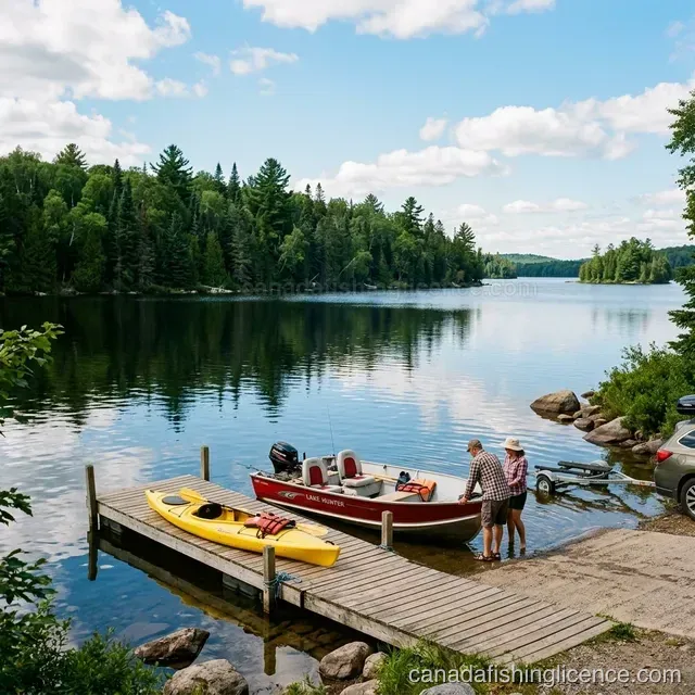
Public boat launches: Best when you already know the waterbody and want reliable entry for a boat, kayak, or cartop craft. Always confirm whether the launch is municipal, park-operated, or attached to a marina before you go.
Shore fishing parks, docks, and municipal waterfronts: These are often the easiest places to start if you are new, fishing with kids, or heading out after work. They usually solve the hardest part of access planning: parking, safe entry, and a clear place to stand.
Crown land or public land corridors: This is where many anglers find quiet shorelines, forest-road lakes, and simple overnight options. The tradeoff is that you have to do more homework, because boundaries, road conditions, and permitted uses are not always obvious on the ground.
Stocked lakes and community ponds: If your main goal is a straightforward day with a realistic chance of catching fish, stocked waters often make more sense than chasing a famous lake. In BC, Ontario, and several other provinces, these waters are easier to research and easier to access.
Ontario Crown Land Basics That Matter in Practice
Ontario is a useful example because its rules are clearly published. The province states that private, non-commercial camping is allowed for up to 21 days on most Crown land sites in a calendar year, after which you must move at least 100 metres. It also makes clear that you cannot camp on roads, trails, parking lots, or boat launches.
That matters for anglers because many first-time Crown land trips fail for simple reasons: the pull-off is only a road shoulder, the shoreline lot is private, or the intended campsite is actually a launch or access lane. Checking the atlas and the land-use notes before you drive saves a lot of wasted time.
If you are a non-resident planning a northern Ontario trip, read the non-resident sections on the Crown land page as well. Some areas require a permit, so do not assume that a public shoreline automatically means you can camp there overnight.
Move Boats and Gear Carefully Between Waters
If you are hauling a boat, float tube, paddleboard, or even waders and landing nets from one waterbody to another, make cleaning part of the trip plan. Parks Canada and provincial agencies use the same basic message: clean off mud and plants, drain standing water, and dry gear before entering a new waterbody.
This matters even more if your trip crosses regions. Some park waters and protected areas have extra inspection or certification steps before a boat can launch, so check that before you tow for several hours only to be turned around at the gate.
A Simple Research Routine That Works
Step 1: Pick the waterbody in an official fishing map or regulations tool. Confirm species, access notes, and season.
Step 2: Find the actual entry point. You are looking for a launch, dock, road-end shore access, or park shoreline, not just the lake itself on a map.
Step 3: Check who manages the access. Municipal, park, Crown land, or private marina all work differently on the ground.
Step 4: Check parking, hours, and any local restrictions. These details usually matter more than the fishing report.
Step 5: Save a backup access point. Good public spots can be full, muddy, closed for maintenance, or windblown when you arrive.
When the Easy-Access Option Is the Better Trip
A lot of anglers over-plan for remoteness when they really want a clean half day on the water. If you are fishing with children, trying a new province, traveling without a boat, or fitting a trip around work, the better choice is often the simple one: a stocked lake, a maintained dock, a park shoreline, or a well-known urban launch.
That kind of trip is easier to repeat, easier to learn from, and much less likely to turn into a long drive followed by a locked gate. If that sounds closer to what you want, our stocked lakes guide, family fishing guide, and free fishing finder are better starting points than a remote-lake fantasy.
Quick Decisions for Common Access Scenarios
I want shore fishing without much walking: Use an official map that includes docks, piers, or shoreline access filters. In BC, GoFishBC does this well.
I want a backroad lake: Check the public-land map first, then the fishing rules, then your parking and turnaround options.
I want to launch a small boat: Confirm whether the ramp is public, whether the road is suitable, and whether there are local launch rules or fees.
I want a one-night fishing trip: Match a legal access point with a nearby campground, recreation site, or permitted Crown land stay rather than assuming you can sleep anywhere beside the water.
I want the easiest beginner trip: Choose a stocked lake or city-access water with a dock or maintained shore. It is usually the most reliable path to a good first outing.